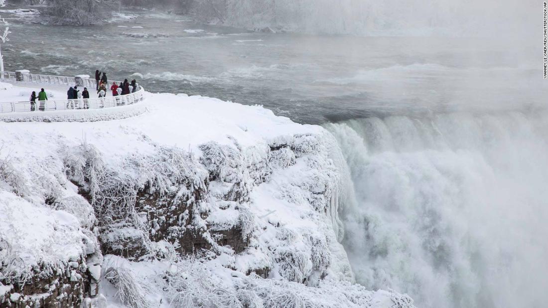

(CNN)A massive “bombogenesis” — an area of rapidly declining low pressure — will wreak havoc on the Northeast this week, threatening hurricane-force winter wind gusts and blinding snow.


By the end of this week, parts of the Northeast will be colder than Mars.
The impending storm led to more than 2,700 preemptive US flight cancellations for Thursday, according to Flightaware.com.
More than 13,000 tons of salt have been scattered across the state, Gov. Henry McMaster said.
Steady snowfall blanketed Charleston in snow and ice, transforming a city that rarely sees snow into a winter wonderland. If Charleston gets four inches of snow on Wednesday as predicted, it would be the most in one day since 1989, CNN meteorologist Brandon Miller said.

McMaster urged people to stay indoors as much as possible to minimize risk of injury.

State of emergency in Georgia
In Georgia, Gov. Nathan Deal issued a state of emergency for 28 coastal counties ahead of Wednesday’s storm.

In Savannah, layers of snow covered live oak trees and Spanish moss.

The bitter conditions extended through the state. In the south-central city of Tifton, Matthew Stuart Reid shot drone footage of the snowfall, set to the music of “Winter Wonderland.”
Florida gets walloped with snow
From Maine to Florida, every East Coast state has at least one weather advisory, winter storm watch, winter storm warning or blizzard warning. That’s 1,500 miles of severe weather alerts.
In Tallahassee, Florida, Ernst Beliard said he’s never seen snow in his 21 years there. Indeed, Tallahassee had not seen measurable snowfall since 1989, CNN meteorologist Michael Guy said.
Deadly freeze
At least 12 people in the US have died this week in cold-related deaths, officials said.
Six deaths were reported in Wisconsin, four in Texas, one in North Dakota and one in Missouri.
Bone-chilling cold, intense snow in Northeast
The bombogenesis will usher in another round of single-digit or sub-zero temperatures to the Northeast. New York City hasn’t warmed up above freezing since Christmas — and the deep freeze will just get worse as snow approaches.
With 4-6 inches of snowfall expected in New York, sanitation workers are getting ready to deploy 2,200 plows to help clear the streets. That snow, combined with “exceptionally strong winds,” means crews will be working in near-whiteout conditions, New York City Sanitation Commissioner Kathryn Garcia said.
New York City schools will be closed Thursday due to the impending snowstorm, Mayor Bill de Blasio said. In Connecticut, where the storm is expected to hit after midnight, Gov. Dan Malloy urged motorists to stay off the roads if possible.
In Massachusetts, snow is expected to fall at a rate of 1-2 inches per hour starting early Thursday, Gov. Charlie Baker said. About 12 inches of snow are expected in Boston, as well as the eastern and central parts of the state. The greatest concern is along the Plymouth County coast and the area from Sandwich to Dennis on Cape Cod.
In southeast Massachusetts, the day may start with freezing rain on the Cape and the islands, Baker said. By midday, a dip in temperatures may bring snow, high winds and possible flooding from “astronomically high tide,” Baker said.
Some of the cities breaking record-high temps include Los Angeles (85 degrees last Friday) and Fort Collins, Colorado (68 degrees last Friday).
Read more: http://edition.cnn.com/